About Delaware ZIP code areas
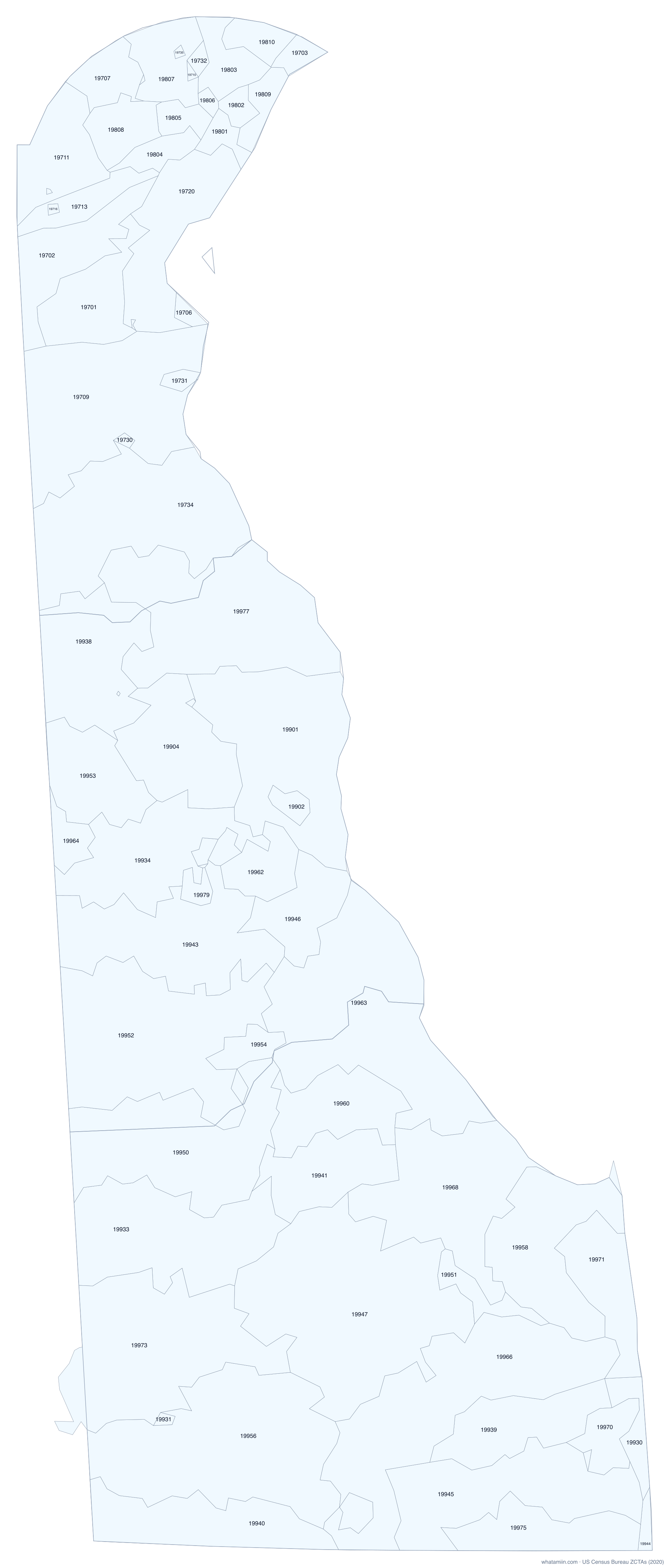
Delaware has 68 ZIP code tabulation areas (ZCTAs), the Census Bureau's area version of ZIP codes. New Castle County has the most, with 29. 6 of them cross a county line, which is why a ZIP code alone cannot always tell you the county. The largest by land is 19947 at 119.2 square miles.
ZIP codes are mail routes, so the Postal Service has no official boundary map. ZCTAs are built from the ZIP code most common in each census block in 2020. PO-box-only ZIPs and single-building ZIPs have no area and are not on this map. For the exact ZIP area at your location, use what ZIP code am I in.
All Delaware ZIP codes
| ZIP | Main city or place | County | Land (sq mi) |
|---|---|---|---|
| 19701 | Bear (CDP) | New Castle | 26.6 |
| 19702 | Glasgow (CDP) | New Castle | 28.1 |
| 19703 | Claymont (CDP) | New Castle | 4.0 |
| 19706 | Delaware City | New Castle | 2.5 |
| 19707 | Hockessin (CDP) | New Castle | 13.2 |
| 19709 | Middletown town | New Castle | 77.6 |
| 19710 | Unincorporated | New Castle | 0.5 |
| 19711 | Newark | New Castle | 27.4 |
| 19713 | Brookside (CDP) | New Castle | 13.0 |
| 19716 | Newark | New Castle | 0.6 |
| 19717 | Newark | New Castle | 0.3 |
| 19720 | New Castle | New Castle | 38.3 |
| 19730 | Odessa town | New Castle | 0.7 |
| 19731 | Port Penn (CDP) | New Castle | 2.5 |
| 19732 | Unincorporated | New Castle | 1.8 |
| 19733 | St. Georges (CDP) | New Castle | 0.1 |
| 19734 | Townsend town | New Castle | 79.9 |
| 19735 | Unincorporated | New Castle | 0.4 |
| 19736 | Hockessin (CDP) | New Castle | 0.2 |
| 19801 | Wilmington | New Castle | 4.4 |
| 19802 | Wilmington | New Castle | 3.5 |
| 19803 | Wilmington | New Castle | 12.7 |
| 19804 | Newport town | New Castle | 7.2 |
| 19805 | Wilmington | New Castle | 5.5 |
| 19806 | Wilmington | New Castle | 1.7 |
| 19807 | Greenville (CDP) | New Castle | 18.2 |
| 19808 | Pike Creek (CDP) | New Castle | 13.8 |
| 19809 | Wilmington | New Castle | 6.8 |
| 19810 | Arden village | New Castle | 7.9 |
| 19901 | Dover | Kent | 75.8 |
| 19902 | Dover | Kent | 3.9 |
| 19904 | Dover | Kent | 43.2 |
| 19930 | Bethany Beach town | Sussex | 5.8 |
| 19931 | Bethel town | Sussex | 1.2 |
| 19933 | Bridgeville town | Sussex | 67.3 |
| 19934 | Camden town | Kent | 46.6 |
| 19936 | Cheswold town | Kent | 0.2 |
| 19938 | Clayton town | Kent, New Castle | 48.2 |
| 19939 | Dagsboro town | Sussex | 26.0 |
| 19940 | Delmar town | Sussex | 41.3 |
| 19941 | Ellendale town | Sussex | 30.3 |
| 19943 | Riverview (CDP) | Kent | 62.4 |
| 19944 | Fenwick Island town | Sussex | 1.2 |
| 19945 | Millville town | Sussex | 62.3 |
| 19946 | Frederica town | Kent | 23.1 |
| 19947 | Georgetown town | Sussex | 119.2 |
| 19950 | Greenwood town | Sussex, Kent | 72.4 |
| 19951 | Unincorporated | Sussex | 8.9 |
| 19952 | Harrington | Kent, Sussex | 91.0 |
| 19953 | Hartly town | Kent | 29.9 |
| 19954 | Houston town | Kent | 9.8 |
| 19955 | Kenton town | Kent | 0.1 |
| 19956 | Laurel town | Sussex | 100.4 |
| 19958 | Lewes | Sussex | 47.3 |
| 19960 | Lincoln (CDP) | Sussex | 30.3 |
| 19962 | Rising Sun-Lebanon (CDP) | Kent | 14.6 |
| 19963 | Milford | Sussex, Kent | 105.1 |
| 19964 | Unincorporated | Kent | 8.1 |
| 19966 | Millsboro town | Sussex | 89.1 |
| 19967 | Millville town | Sussex | 1.6 |
| 19968 | Milton town | Sussex | 63.9 |
| 19970 | Ocean View town | Sussex | 9.3 |
| 19971 | Rehoboth Beach | Sussex | 18.0 |
| 19973 | Seaford | Sussex, Dorchester | 84.0 |
| 19975 | Selbyville town | Sussex | 25.5 |
| 19977 | Smyrna town | Kent, New Castle | 83.1 |
| 19979 | Viola town | Kent | 3.3 |
| 19980 | Woodside town | Kent | 0.2 |
Download as CSV. County order shows where most of the ZIP's land lies.
See also: Delaware county map · Delaware counties · ZIP codes in a radius · study: ZIP codes that cross county lines