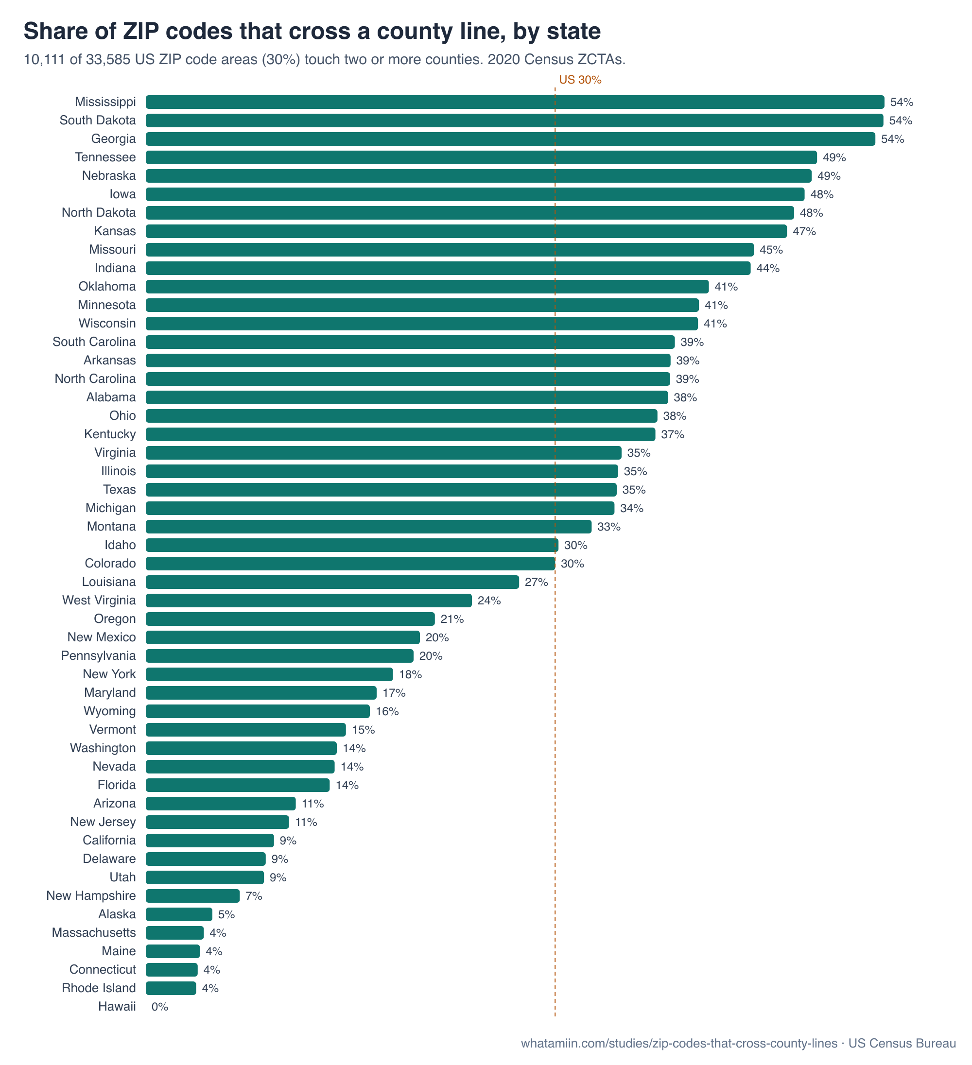
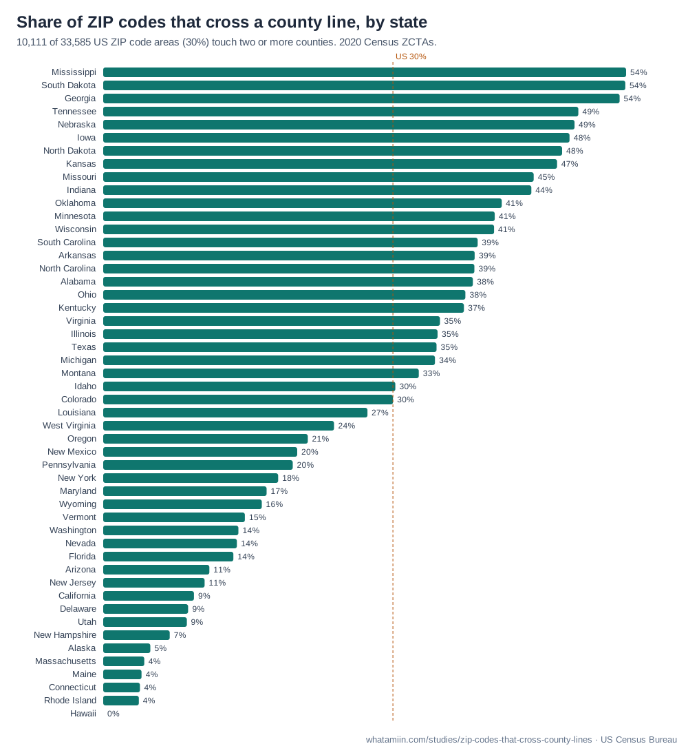
ZIP codes are drawn for mail delivery, not for governments. When we matched every 2020 ZIP Code Tabulation Area (ZCTA) to the counties it overlaps, 10,111 of 33,585 (30.1%) crossed at least one county line. In 7,658 of them (23% of all ZIPs) the smaller side holds at least 5% of the ZIP's area, so the split is more than a sliver along a boundary road. 390 ZIPs touch four or more counties, and ZIP 39573 touches 6.
The share swings widely by state: 54% of ZIPs in Mississippi cross a county line, against 0% in Hawaii. States with many small counties and long rural mail routes split the most ZIPs.
Why it matters
Many spreadsheets, CRMs and tax tools assign a county from the ZIP code alone. For roughly a third of ZIPs that guess is wrong for some of the addresses in it. That matters for sales tax, property and insurance rating, voter and jury lists, health reporting and any analysis grouped by county. The fix is to place the full street address and test which county contains it. Our free address to county tool does that for one address or a CSV of 1,000, and the spreadsheet guide walks through it.
Every state
| State | ZIP codes | Cross a county line | Share | Split ≥5% of area | ZIP touching most counties |
|---|---|---|---|---|---|
| Mississippi | 427 | 232 | 54% | 179 | 39573 (6) |
| South Dakota | 376 | 204 | 54% | 163 | 57638 (5) |
| Georgia | 751 | 403 | 54% | 289 | 30233 (5) |
| Tennessee | 638 | 315 | 49% | 235 | 37110 (5) |
| Nebraska | 586 | 287 | 49% | 237 | 68823 (6) |
| Iowa | 970 | 470 | 48% | 380 | 50864 (5) |
| North Dakota | 388 | 185 | 48% | 160 | 58638 (5) |
| Kansas | 704 | 332 | 47% | 277 | 66736 (5) |
| Missouri | 1,035 | 463 | 45% | 375 | 65243 (5) |
| Indiana | 807 | 359 | 44% | 238 | 47240 (5) |
| Oklahoma | 664 | 275 | 41% | 217 | 73073 (4) |
| Minnesota | 880 | 358 | 41% | 291 | 56464 (5) |
| Wisconsin | 783 | 318 | 41% | 232 | 53066 (4) |
| South Carolina | 424 | 165 | 39% | 125 | 29654 (4) |
| Arkansas | 614 | 237 | 39% | 176 | 71603 (4) |
| North Carolina | 853 | 329 | 39% | 231 | 28127 (5) |
| Alabama | 656 | 252 | 38% | 199 | 35016 (4) |
| Ohio | 1,233 | 464 | 38% | 322 | 43011 (4) |
| Kentucky | 779 | 292 | 37% | 209 | 40361 (5) |
| Virginia | 903 | 316 | 35% | 236 | 22630 (5) |
| Illinois | 1,396 | 485 | 35% | 365 | 60010 (4) |
| Texas | 1,989 | 689 | 35% | 537 | 75494 (4) |
| Michigan | 992 | 342 | 34% | 252 | 48624 (4) |
| Montana | 369 | 121 | 33% | 94 | 59301 (5) |
| Idaho | 280 | 85 | 30% | 58 | 83120 (3) |
| Colorado | 528 | 159 | 30% | 126 | 80020 (4) |
| Louisiana | 539 | 148 | 27% | 109 | 71418 (5) |
| West Virginia | 738 | 177 | 24% | 141 | 26143 (4) |
| Oregon | 428 | 91 | 21% | 69 | 97035 (3) |
| New Mexico | 372 | 75 | 20% | 62 | 87013 (3) |
| Pennsylvania | 1,833 | 361 | 20% | 274 | 16127 (4) |
| New York | 1,826 | 332 | 18% | 228 | 12010 (4) |
| Maryland | 477 | 81 | 17% | 58 | 21771 (4) |
| Wyoming | 176 | 29 | 16% | 24 | 82701 (5) |
| Vermont | 265 | 39 | 15% | 27 | 05060 (3) |
| Washington | 605 | 85 | 14% | 61 | 98568 (3) |
| Nevada | 180 | 25 | 14% | 17 | 89010 (3) |
| Florida | 1,013 | 137 | 14% | 104 | 32008 (4) |
| Arizona | 417 | 46 | 11% | 40 | 85611 (3) |
| New Jersey | 598 | 63 | 11% | 47 | 08344 (4) |
| California | 1,803 | 170 | 9% | 120 | 93252 (4) |
| Delaware | 68 | 6 | 9% | 5 | 19938 (2) |
| Utah | 299 | 26 | 9% | 22 | 84034 (3) |
| New Hampshire | 246 | 17 | 7% | 3 | 03104 (3) |
| Alaska | 245 | 12 | 5% | 11 | 99760 (3) |
| Massachusetts | 539 | 23 | 4% | 12 | 01082 (3) |
| Maine | 427 | 17 | 4% | 17 | 03579 (2) |
| Connecticut | 288 | 11 | 4% | 3 | 06065 (2) |
| Rhode Island | 81 | 3 | 4% | 1 | 02816 (2) |
| Hawaii | 97 | 0 | 0% | 0 | 96701 (1) |
Each ZIP is counted in the state holding most of its area. State names link to that state's ZIP code map.
The ZIPs that touch the most counties
| ZIP | Counties | Counties it touches (largest share first) |
|---|---|---|
| 39573 | 6 | Stone County, MS; George County, MS; Hancock County, MS; Jackson County, MS; Pearl River County, MS; Harrison County, MS |
| 68823 | 6 | Garfield County, NE; Loup County, NE; Rock County, NE; Valley County, NE; Holt County, NE; Custer County, NE |
| 22630 | 5 | Warren County, VA; Frederick County, VA; Clarke County, VA; Fauquier County, VA; Rappahannock County, VA |
| 23847 | 5 | Greensville County, VA; Brunswick County, VA; Southampton County, VA; Sussex County, VA; Emporia city, VA |
| 28127 | 5 | Stanly County, NC; Montgomery County, NC; Davidson County, NC; Rowan County, NC; Randolph County, NC |
| 30233 | 5 | Butts County, GA; Monroe County, GA; Henry County, GA; Lamar County, GA; Newton County, GA |
| 30534 | 5 | Dawson County, GA; Lumpkin County, GA; Forsyth County, GA; Pickens County, GA; Cherokee County, GA |
| 31061 | 5 | Baldwin County, GA; Wilkinson County, GA; Hancock County, GA; Putnam County, GA; Jones County, GA |
| 37110 | 5 | Warren County, TN; Grundy County, TN; Van Buren County, TN; Cannon County, TN; Sequatchie County, TN |
| 37144 | 5 | Lincoln County, TN; Marshall County, TN; Bedford County, TN; Moore County, TN; Giles County, TN |
| 37846 | 5 | Loudon County, TN; Roane County, TN; Monroe County, TN; McMinn County, TN; Meigs County, TN |
| 38583 | 5 | White County, TN; DeKalb County, TN; Putnam County, TN; Cumberland County, TN; Van Buren County, TN |
| 38824 | 5 | Prentiss County, MS; Lee County, MS; Union County, MS; Itawamba County, MS; Tippah County, MS |
| 39365 | 5 | Neshoba County, MS; Newton County, MS; Leake County, MS; Kemper County, MS; Scott County, MS |
| 39455 | 5 | Lamar County, MS; Pearl River County, MS; Forrest County, MS; Stone County, MS; Marion County, MS |
| 40361 | 5 | Bourbon County, KY; Harrison County, KY; Fayette County, KY; Nicholas County, KY; Montgomery County, KY |
| 47240 | 5 | Decatur County, IN; Shelby County, IN; Franklin County, IN; Ripley County, IN; Rush County, IN |
| 50864 | 5 | Montgomery County, IA; Page County, IA; Taylor County, IA; Adams County, IA; Cass County, IA |
| 56464 | 5 | Wadena County, MN; Becker County, MN; Hubbard County, MN; Otter Tail County, MN; Cass County, MN |
| 57638 | 5 | Perkins County, SD; Adams County, ND; Grant County, ND; Sioux County, ND; Corson County, SD |
All 137 ZIP codes that cross a state line
Most are rural routes served from a post office just across the border. "Minor side" is the share of the ZIP's area in the state that holds less of it.
| ZIP | States | Minor side | Counties |
|---|---|---|---|
| 02861 | MA / RI | 0.4% | Providence County, RI; Bristol County, MA |
| 03579 | ME / NH | 41.6% | Oxford County, ME; Coos County, NH |
| 19973 | DE / MD | 7.2% | Sussex County, DE; Dorchester County, MD |
| 20135 | VA / WV | 0.7% | Clarke County, VA; Loudoun County, VA; Jefferson County, WV |
| 21874 | DE / MD | 0.5% | Wicomico County, MD; Sussex County, DE |
| 21912 | DE / MD | 0.2% | Cecil County, MD; New Castle County, DE |
| 24604 | VA / WV | 20.0% | Tazewell County, VA; McDowell County, WV |
| 24622 | VA / WV | 12.6% | Buchanan County, VA; Tazewell County, VA; McDowell County, WV |
| 27048 | NC / VA | 1.4% | Rockingham County, NC; Henry County, VA |
| 28675 | NC / VA | 0.7% | Alleghany County, NC; Grayson County, VA; Wilkes County, NC |
| 30165 | AL / GA | 1.0% | Floyd County, GA; Cherokee County, AL; Chattooga County, GA |
| 30741 | GA / TN | 0.1% | Walker County, GA; Catoosa County, GA; Hamilton County, TN |
| 36855 | AL / GA | 1.1% | Chambers County, AL; Troup County, GA |
| 37642 | TN / VA | 0.5% | Hawkins County, TN; Scott County, VA |
| 37752 | TN / VA | 0.6% | Claiborne County, TN; Lee County, VA |
| 38079 | KY / TN | 12.9% | Lake County, TN; Fulton County, KY |
| 38326 | MS / TN | 1.3% | Hardin County, TN; Tishomingo County, MS |
| 38549 | KY / TN | 1.8% | Pickett County, TN; Fentress County, TN; Clinton County, KY |
| 38769 | AR / MS | 8.5% | Bolivar County, MS; Desha County, AR |
| 38852 | AL / MS | 0.3% | Tishomingo County, MS; Colbert County, AL |
| 40965 | KY / TN | 15.0% | Bell County, KY; Claiborne County, TN |
| 42223 | KY / TN | 44.9% | Montgomery County, TN; Christian County, KY |
| 42602 | KY / TN | 0.2% | Clinton County, KY; Russell County, KY; Wayne County, KY; Pickett County, TN |
| 51001 | IA / SD | 39.8% | Plymouth County, IA; Union County, SD |
| 51023 | IA / SD | 29.6% | Sioux County, IA; Union County, SD |
| 51360 | IA / MN | 2.8% | Dickinson County, IA; Jackson County, MN |
| 51557 | IA / NE | 10.8% | Harrison County, IA; Burt County, NE |
| 51640 | IA / MO | 18.4% | Fremont County, IA; Atchison County, MO |
| 52542 | IA / MO | 19.6% | Van Buren County, IA; Scotland County, MO |
| 52573 | IA / MO | 34.7% | Van Buren County, IA; Clark County, MO; Scotland County, MO |
| 52626 | IA / MO | 21.3% | Lee County, IA; Van Buren County, IA; Clark County, MO |
| 54540 | MI / WI | 0.7% | Vilas County, WI; Gogebic County, MI |
| 56027 | IA / MN | 13.4% | Faribault County, MN; Kossuth County, IA; Martin County, MN |
| 56136 | MN / SD | 22.4% | Lincoln County, MN; Brookings County, SD |
| 56144 | MN / SD | 13.1% | Rock County, MN; Pipestone County, MN; Moody County, SD |
| 56164 | MN / SD | 3.4% | Pipestone County, MN; Lincoln County, MN; Moody County, SD |
| 56219 | MN / SD | 44.9% | Roberts County, SD; Traverse County, MN; Big Stone County, MN |
| 56220 | MN / SD | 0.2% | Yellow Medicine County, MN; Lac qui Parle County, MN; Lincoln County, MN; Deuel County, SD |
| 56257 | MN / SD | 5.0% | Lac qui Parle County, MN; Deuel County, SD |
| 56744 | MN / ND | 26.8% | Marshall County, MN; Polk County, MN; Walsh County, ND; Grand Forks County, ND |
| 57026 | MN / SD | 23.3% | Brookings County, SD; Moody County, SD; Lincoln County, MN; Pipestone County, MN |
| 57030 | MN / SD | 10.0% | Minnehaha County, SD; Rock County, MN |
| 57034 | IA / SD | 7.7% | Lincoln County, SD; Union County, SD; Sioux County, IA |
| 57068 | MN / SD | 6.8% | Minnehaha County, SD; Rock County, MN |
| 57255 | ND / SD | 4.5% | Roberts County, SD; Richland County, ND |
| 57430 | ND / SD | 0.9% | Marshall County, SD; Sargent County, ND |
| 57638 | ND / SD | 34.8% | Perkins County, SD; Adams County, ND; Grant County, ND; Sioux County, ND; Corson County, SD |
| 57641 | ND / SD | 37.4% | Corson County, SD; Sioux County, ND; Grant County, ND |
| 57642 | ND / SD | 2.8% | Corson County, SD; Sioux County, ND |
| 57645 | ND / SD | 48.0% | Corson County, SD; Grant County, ND; Sioux County, ND |
| 57648 | ND / SD | 47.4% | Campbell County, SD; Emmons County, ND |
| 57660 | ND / SD | 12.0% | Corson County, SD; Sioux County, ND |
| 57717 | MT / SD / WY | 25.2% | Butte County, SD; Crook County, WY; Carter County, MT; Harding County, SD; Lawrence County, SD |
| 57724 | MT / SD | 37.3% | Harding County, SD; Carter County, MT |
| 57735 | NE / SD | 1.9% | Fall River County, SD; Custer County, SD; Sioux County, NE |
| 58030 | MN / ND | 1.3% | Richland County, ND; Wilkin County, MN |
| 58041 | ND / SD | 0.8% | Richland County, ND; Roberts County, SD |
| 58043 | ND / SD | 4.9% | Sargent County, ND; Marshall County, SD |
| 58053 | ND / SD | 7.9% | Richland County, ND; Sargent County, ND; Roberts County, SD; Marshall County, SD |
| 58225 | MN / ND | 11.4% | Pembina County, ND; Walsh County, ND; Kittson County, MN |
| 58413 | ND / SD | 6.6% | McIntosh County, ND; Dickey County, ND; McPherson County, SD |
| 58436 | ND / SD | 4.6% | Dickey County, ND; Brown County, SD |
| 58439 | ND / SD | 37.1% | Dickey County, ND; McPherson County, SD; Brown County, SD |
| 58568 | ND / SD | 0.4% | Sioux County, ND; Corson County, SD |
| 58621 | MT / ND | 4.4% | Golden Valley County, ND; Wibaux County, MT; McKenzie County, ND; Billings County, ND |
| 58623 | ND / SD | 1.9% | Bowman County, ND; Slope County, ND; Harding County, SD |
| 58639 | ND / SD | 21.2% | Adams County, ND; Perkins County, SD |
| 58649 | ND / SD | 9.5% | Adams County, ND; Hettinger County, ND; Harding County, SD; Bowman County, ND; Slope County, ND |
| 58653 | ND / SD | 14.6% | Bowman County, ND; Harding County, SD; Slope County, ND |
| 59221 | MT / ND | 15.9% | Richland County, MT; McKenzie County, ND |
| 59270 | MT / ND | 39.4% | Richland County, MT; McKenzie County, ND |
| 59275 | MT / ND | 24.3% | Sheridan County, MT; Divide County, ND |
| 59847 | ID / MT | 5.2% | Missoula County, MT; Idaho County, ID |
| 63673 | IL / MO | 21.6% | Ste. Genevieve County, MO; Perry County, MO; Randolph County, IL |
| 65729 | AR / MO | 10.8% | Ozark County, MO; Marion County, AR |
| 65733 | AR / MO | 18.8% | Taney County, MO; Marion County, AR; Boone County, AR; Ozark County, MO |
| 65761 | AR / MO | 18.0% | Ozark County, MO; Taney County, MO; Marion County, AR |
| 66541 | KS / NE | 28.0% | Marshall County, KS; Pawnee County, NE |
| 66955 | KS / NE | 22.2% | Washington County, KS; Thayer County, NE |
| 68325 | KS / NE | 45.0% | Thayer County, NE; Republic County, KS |
| 68327 | KS / NE | 34.1% | Thayer County, NE; Republic County, KS |
| 68420 | KS / NE | 2.4% | Pawnee County, NE; Nemaha County, KS |
| 68719 | NE / SD | 39.9% | Boyd County, NE; Gregory County, SD |
| 68755 | NE / SD | 0.4% | Boyd County, NE; Gregory County, SD |
| 68943 | KS / NE | 11.9% | Nuckolls County, NE; Republic County, KS; Thayer County, NE |
| 68978 | KS / NE | 15.4% | Nuckolls County, NE; Jewell County, KS |
| 69026 | KS / NE | 35.7% | Red Willow County, NE; Decatur County, KS |
| 69168 | CO / NE | 4.4% | Perkins County, NE; Chase County, NE; Sedgwick County, CO |
| 69201 | NE / SD | 16.7% | Cherry County, NE; Todd County, SD |
| 69212 | NE / SD | 42.9% | Cherry County, NE; Todd County, SD |
| 69216 | NE / SD | 29.1% | Cherry County, NE; Todd County, SD |
| 69337 | NE / SD | 14.5% | Dawes County, NE; Oglala Lakota County, SD; Sheridan County, NE; Fall River County, SD |
| 71749 | AR / LA | 1.8% | Union County, AR; Claiborne Parish, LA; Union Parish, LA |
| 71937 | AR / OK | 6.2% | Polk County, AR; McCurtain County, OK |
| 71953 | AR / OK | 5.1% | Polk County, AR; Scott County, AR; Le Flore County, OK |
| 72338 | AR / TN | 33.3% | Tipton County, TN; Mississippi County, AR |
| 72644 | AR / MO | 1.2% | Boone County, AR; Marion County, AR; Taney County, MO |
| 73949 | OK / TX | 13.6% | Texas County, OK; Cimarron County, OK; Sherman County, TX |
| 75556 | AR / TX | 0.9% | Cass County, TX; Miller County, AR |
| 79835 | NM / TX | 1.2% | El Paso County, TX; Doña Ana County, NM |
| 79837 | NM / TX | 18.2% | Otero County, NM; Hudspeth County, TX |
| 79922 | NM / TX | 16.9% | El Paso County, TX; Doña Ana County, NM |
| 80737 | CO / NE | 3.8% | Sedgwick County, CO; Deuel County, NE |
| 81120 | CO / NM | 7.9% | Conejos County, CO; Rio Arriba County, NM |
| 81137 | CO / NM | 19.3% | La Plata County, CO; San Juan County, NM; Archuleta County, CO |
| 81324 | CO / UT | 47.1% | Dolores County, CO; San Juan County, UT |
| 82063 | CO / WY | 20.2% | Larimer County, CO; Albany County, WY |
| 82082 | CO / NE / WY | 29.3% | Laramie County, WY; Banner County, NE; Kimball County, NE; Weld County, CO |
| 82701 | SD / WY | 7.9% | Weston County, WY; Niobrara County, WY; Campbell County, WY; Custer County, SD; Pennington County, SD |
| 82801 | MT / WY | 2.6% | Sheridan County, WY; Big Horn County, MT |
| 82930 | UT / WY | 29.6% | Summit County, UT; Uinta County, WY |
| 83120 | ID / WY | 10.0% | Bonneville County, ID; Caribou County, ID; Lincoln County, WY |
| 83127 | ID / WY | 47.8% | Lincoln County, WY; Caribou County, ID |
| 83342 | ID / UT | 13.3% | Cassia County, ID; Oneida County, ID; Box Elder County, UT |
| 83856 | ID / WA | 8.0% | Bonner County, ID; Pend Oreille County, WA |
| 84034 | NV / UT | 9.2% | Tooele County, UT; Juab County, UT; White Pine County, NV |
| 84531 | AZ / UT | 21.2% | San Juan County, UT; Apache County, AZ |
| 84536 | AZ / UT | 2.7% | San Juan County, UT; Navajo County, AZ |
| 86044 | AZ / UT | 31.5% | Coconino County, AZ; San Juan County, UT; Navajo County, AZ |
| 86504 | AZ / NM | 1.3% | Apache County, AZ; McKinley County, NM |
| 86514 | AZ / NM / UT | 16.1% | Apache County, AZ; San Juan County, UT; San Juan County, NM |
| 86515 | AZ / NM | 11.8% | McKinley County, NM; Apache County, AZ |
| 87328 | AZ / NM | 38.6% | Apache County, AZ; McKinley County, NM; San Juan County, NM |
| 88430 | NM / TX | 2.7% | Quay County, NM; Union County, NM; Oldham County, TX |
| 89010 | CA / NV | 3.8% | Esmeralda County, NV; Mineral County, NV; Mono County, CA |
| 89019 | CA / NV | 22.4% | Clark County, NV; San Bernardino County, CA; Inyo County, CA |
| 89060 | CA / NV | 1.9% | Nye County, NV; Inyo County, CA |
| 89061 | CA / NV | 4.4% | Nye County, NV; Inyo County, CA |
| 89421 | NV / OR | 38.9% | Malheur County, OR; Humboldt County, NV |
| 89439 | CA / NV | 25.5% | Washoe County, NV; Sierra County, CA |
| 89832 | ID / NV | 33.0% | Elko County, NV; Owyhee County, ID |
| 97635 | CA / OR | 7.2% | Modoc County, CA; Lake County, OR |
| 97910 | ID / OR | 7.6% | Malheur County, OR; Owyhee County, ID |
| 97913 | ID / OR | 0.1% | Malheur County, OR; Payette County, ID |
| 99033 | ID / WA | 1.9% | Whitman County, WA; Spokane County, WA; Benewah County, ID |
| 99128 | ID / WA | 7.5% | Whitman County, WA; Latah County, ID |
| 99362 | OR / WA | 8.4% | Walla Walla County, WA; Umatilla County, OR |
Method
We used the Census Bureau's 2020 ZCTA-to-county relationship file, which lists every piece of land and water where a ZIP Code Tabulation Area and a county overlap. A ZIP "crosses a county line" if it overlaps more than one county. ZCTAs are the Census Bureau's area version of ZIP codes. PO-box-only and single-building ZIPs have no area and are not included, and ZCTAs can differ slightly from current USPS routes. Puerto Rico and other territories are left out.
Republishing: journalists, teachers and researchers may use these tables, figures and the chart with a link to this page. The chart is free under CC BY 4.0.